


12102D - 02D Voting District, Fulton County, Georgia
About
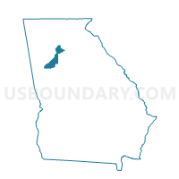
Outline

Summary
| Unique Area Identifier | 561573 |
| Name | 12102D - 02D Voting District |
| County | Fulton County |
| State | Georgia |
| Area (square miles) | 0.55 |
| Land Area (square miles) | 0.55 |
| Water Area (square miles) | 0.00 |
| % of Land Area | 100.00 |
| % of Water Area | 0.00 |
| Latitude of the Internal Point | 33.76627250 |
| Longtitude of the Internal Point | -84.36938430 |
Maps


Graphs
Select a template below for downloading or customizing gragh for 12102D - 02D Voting District, Fulton County, Georgia


Neighbors
Neighoring Voting District (by Name) Neighboring Voting District on the Map
- 12102C - 02C Voting District, Fulton County, GA
- 12102F1 - 02F1 Voting District, Fulton County, GA
- 12102F2 - 02F2 Voting District, Fulton County, GA
- 12102G - 02G Voting District, Fulton County, GA
- 12102S - 02S Voting District, Fulton County, GA
Top 10 Neighboring County Subdivision (by Population) Neighboring County Subdivision on the Map
Top 10 Neighboring Place (by Population) Neighboring Place on the Map
Top 10 Neighboring Unified School District (by Population) Neighboring Unified School District on the Map
Top 10 Neighboring State Legislative District Lower Chamber (by Population) Neighboring State Legislative District Lower Chamber on the Map
Top 10 Neighboring State Legislative District Upper Chamber (by Population) Neighboring State Legislative District Upper Chamber on the Map
Top 10 Neighboring 111th Congressional District (by Population) Neighboring 111th Congressional District on the Map
Top 10 Neighboring Census Tract (by Population) Neighboring Census Tract on the Map
- Census Tract 13, Fulton County, GA (4,073)
- Census Tract 18, Fulton County, GA (3,927)
- Census Tract 28, Fulton County, GA (3,547)
- Census Tract 17, Fulton County, GA (2,800)
- Census Tract 29, Fulton County, GA (2,523)
- Census Tract 14, Fulton County, GA (2,182)
- Census Tract 16, Fulton County, GA (2,072)